Tuesday, May 30, 2000

Background


This is an account of a drive starting June 11, 2010 from our Maine home to Gaspe to Labrador to Newfoundland to Nova Scotia and back home, in our 2006 Prius.  We are Dick and Margery Dreselly, very senior citizens who retired in 1987 to Brunswick, Maine.  In 2021 we're in a "senior complex" in South Portland, Maine.  To show what we looked like, here's a 2004 photo, near Cape Horn -->   xx    

The names "Newfoundland" and "Labrador" are confusing.  Their area was called just "Newfoundland" when  it was a separate country, a British dominion with its own postage stamps, until after it became a Canadian province in 1949, with the voters opting for "confederation" with Canada narrowly exceeding those preferring to remain a British dominion or even to become a USA state.  In 2001 the provincial name was changed to "Newfoundland and Labrador".   The Labrador part is mainland north of the St. Lawrence River,  bigger (the size of Arizona) and wilder (population 42,000 with no town population above 10,000) and colder (sub-Arctic).  The Newfoundland part is an island that splits the mouth of the St. Lawrence River, is the size of Virginia, has 480,000 people with 100,000 of them in St. John's, and has an average climate between those of Maine and Labrador.

Labrador was a challenging adventure for us.  On this trip we drove most of its roads, which is a 
1060-mile arc extending north from Baie-Comeau on the St. Lawrence river through Quebec to Labrador City and Goose Bay and back south to the St. Lawrence at Red Bay, Quebec.  The 693 miles of mostly paved road from Baie-Comeau to Goose Bay has been there for several decades.   The 356 mile road from Goose Bay to Red Bay was only a snowmobile trail until a road between those towns was begun in 1986 and officially completed in December 2009, without pavement.  However, on our trip 30 miles of that segment were still under construction.  We're glad we went, but probably won't go to Labrador again, just Newfoundland.

Most of our drive north of the St. Lawrence was sub-Arctic, with very short trees, offshore ice and icebergs and occasional polar bears to July.  For us that also meant very few people, cars, paved roads, facilities, and hours of darkness.  

In May the newest part of the road, from Goose Bay to Cartwright, was snowy and muddy, impassable to cars.  It became barely drivable by cars in late May.   The arc is so new that there wasn't much about it on the Internet, but now see these:  click .  From near Red Bay we crossed on a 1 1/2 hour ferry to the island of Newfoundland, drove the length of that island twice, and arrived home on July 6.

Newfoundland, its wonderful people and scenery, subtly changed our lives.  We were lured there in 1970 by Farley Mowat's book "The Boat Who Wouldn't Float".
We returned in 1999 and 2010. 

************************************** 
If JFK could say, "Ich bin eine Berliner", I can say, "I am Canadian".  We are loyal Americans who also love Canada, and have travelled far in that uncrowded second biggest country in the world.  We admire its government and economy (click).   We know Canada is not perfect, and a few Canadians don't like Americans, but we've liked nearly all the Canadians we've met or read about.


Of those many Canadian B&Bs at which we've stayed, all but one were operated by couples we would have liked as neighbors.   By a slight margin, the friendliest Canadians and most interesting Canadian experiences we've found so far have been in far eastern Canada.   Another overwhelming impression of  Canada is "unspoiled".   That doesn't mean "rural", considering its ultramodern cities, or "backward", considering their greater longevity due to a widely supported medical system,.  We are impressed that although some Canadians are rich, there seem to be hardly any who are obscenely rich or very poor.  
        
We've travelled twice by Toyota and once by Cessna from Maine to Alaska, of course via Canada.   We've driven to all 13 provinces and territories of Canada except Nunavut (click) , the new mostly-aboriginal  nearly-roadless Arctic territory.   We've driven to some of Canada's extreme corners: Victoria BC, Inuvik on the Arctic Ocean, St. John's Newfoundland, and by boat to the northernmost  Inuit (click)  community in Labrador.  We've travelled many times by car and Cessna from home to adjacent New Brunswick (NB) and Nova Scotia.   Twice we've flown the Cessna to Toronto.  Twice we've sailed a sloop to St. John NB and through the Reversing Falls of the St. John River to the placid labyrinth upstream.

When we drove and ferried to Newfoundland in 1999 its economy had been devastated by the near end of cod fishing.    Furnished homes were sold for a pittance ($3,500 or so) by jobless fishermen who migrated to the oil fields of Alberta.  In 2010 we found our assumptions overturned.   Newfoundland had adjusted well.   We asked about the economy in several coastal villages, which all had neatly maintained homes and shiny cars.  Their men worked in western Canada mines, especially in Fort McMurray, Alberta, earning high wages in the oil sands boom.  They came home and remitted money regularly, like Mexicans working in the USA.  In some of those little towns real estate prices had quintupled in 11 years, we were told.

PS on 8-23-2015:  Because oil prices have collapsed to under $50 per barrel, there's far less activity in Fort McMurray, so less money is being remitted to Newfoundland.   Houses there are cheaper again, and also the Canadian dollar has fallen to 76 USA cents.             


Each spring and early summer the "Labrador current" brings a parade of icebergs from Greenland to near the shores of Labrador and Newfoundland.   Sometimes polar bears ride the icebergs until they are near enough to swim to land.   These were early June 2010 warnings from Cartwright, on our route:

"The new road from Cartwright to Goose Bay is open but there remain about 50 kms to be properly finished. It is advised that cars stay off this section yet, as it is quite rough and mud can be deep.".
"A polar bear warning has been issued for the coast of Labrador, the first this year".  
A recent bear sighting in the coastal town of Cartwright had prompted the advisory from the 
Newfoundland and Labrador Department of Natural Resources.    No polar bear advisories have been issued for the island of Newfoundland so far this year. In the past, they have been issued after bears came to the island on pack ice from the north.  The bears get on the pack ice to hunt seals.  Wildlife officials offered this advice to anyone who may encounter a polar bear:
Remain calm.
Give the bear space.
Back away, get out of the situation, but never run.
If you must speak, do so calmly and firmly."

Like "Nice bear, DO NOT eat us".  We only saw black bears.

Besides reading what I've written, you can:
* CLICK on an entry on the list at right to go directly to that subject.
* CLICK on the
 websites in the narrative for more information.
* COMMENT...  by phone (207-352-7064), visit, paper, or email is invited.
You can leave a comment at the end of any subject, like this one: click on the slanted pencil.
* ENLARGE A PHOTO... Just click on it.


For more information on this route and our trip:  click  and  click  .
Since the last road link was finally completed in 2010, we were among the first people to drive it.

If you liked this story you also might like to read DresellyFly.blogspot.com . 

Note: formatting in this blog is quite unpredictable.


Sunday, May 28, 2000

Home-Fredericton-Gaspe-Baie Comeau


We expected our drive around Labrador  would  be exciting and unpredictable, after a pleasant uneventful one week approach..  We left home on June 10, but a piece of chicken lodged in Marge's esophagus, so we diverted to the Brunswick hospital emergency room.  Three hours later she was OK.
Lupines in rural New Brunswick, near Maine
June 11, 12: We set out again, tended family graves in Princeton, Maine, drove many miles of  beautiful lupine-lined back roads, and  checked into the excellent Amsterdam motel in Fredericton, New Brunswick.


We had an appointment to set up a Visa based on our Canadian bank account, but snags in that process took 3 visits, so it was too late to go on, and we booked another night at the Amsterdam.  We enjoyed a short scenic drive down the St. John River to visit friends in the village of Gagetown, which we had visited many times by car over 30 years and twice by auxiliary sloop from Maine.

June 13: We drove the 70 mph Trans-Canada north beside the St. John River, close by the big windmill farm atop Maine's Mars Hill.   Traffic density seemed less than a tenth of that on the average USA Interstate.    At St. Leonard we turned northeast to bilingual Campbelltown NB and on to Quebec's Gaspe Peninsula.   The Gaspe road was an endless series of little towns with quirky architecture, seaside scenery, and never an opportunity to pass the slowest car.   Of the 3 B&B's we had thought we might use there, two were not open for the summer season and one had steep stairs not OK for Marge.  So we continued, arriving at dusk at Perce, famed for its famous "pierced" offshore rock.   We were so anxious to settle down after 380 miles that we paid twice our budget for an elegant hotel and restaurant frequented by Europeans, whose euro makes those prices seem moderate.

June 14:  We got off to our usual late start, and took a last look at Perce and its Rock.

Perce Rock

Village on north side of the Gaspe Peninsula


After we rounded the tip of the Peninsula and headed west along the St. Lawrence shore, the scenery became as beautiful as we remembered from many years ago, steep twisty roads and views that are world famous.
Wind turbines


Gradually old fishing villages were supplanted by modern technology (dozens of wind turbines) and a flat road posted for 90 kph (56 mph) along the base of cliffs.


Looking back at Matane, from ferry bound for north shore
of the St. Lawrence River


We reached the ferry at Matane 15 minutes before loading, without a reservation, for the 2 1/2 hour crossing of the St. Lawrence River to Baie Comeau.   This photo is looking back at Matane.

We had a scare after we left the ferry.   To celebrate our 42nd wedding anniversary and save time, we applied for a room at the best hotel in town.   But the city on the edge of northern wilderness is booming.  Trucks on the ferry were laden with new sewer pipe, there was so much road construction in the city that maps and GPS were useless, and the hotels were apparently fully booked with industrial workers and crews fighting forest fires that are polluting Maine air.  Besides the useless maps and GPS, I'd forgotten most of my French, and here was Quebec French, so we spent 2 hours until dark driving in circles, getting directions that would be unintelligible even in English, and facing a night of sleeping in the car.  Finally we got a bed at a Comfort Inn, and an expensive supper at a bar.


Two old quotes apply to the above:
"An adventure is an inconvenience, rightly considered".
"An adventure is the result of poor planning".

Friday, May 26, 2000

Baie Comeau-Labrador City-Goose Bay


June 15:   We faced a rated 8 hour drive to Labrador City.  That's 215 miles of "winding narrow paved road" and 155 miles of "gravel, straight, beware construction".   There would be 3 stretches with no structures or gasoline for well over 100 miles.  We booked a room in Labrador City, where English is the primary language.  Click on:  Road to Labrador City


Here we went from tourist mode to adventure mode.  The sign means "211 kilometers (133 miles) to the next gasoline.

There were tremendous contrasts in what turned out to be the 372 mile drive from Baie Comeau to Labrador City.  The first 3 hours were on a narrow sinuous paved road through beautiful forest with countless roadside ponds and  a few big lakes.
This is typical of the only road to Goose Bay from Baie Comeau.  The sign means "Road very sinuous for 10 miles".  Actually it was very curvy for well over 100 miles.  Then the road was straighter and flatter, but the surface was worse, sometimes narrower.


Manic 5 dam in the wilderness, one of world's biggest of its type
Manic 5 dam, a little closer


These are photos of the (click) Manic 5 dam, the fifth dam on the former Manicouagan River, which has several world superlatives..  If you click on that, also click on its slide show.


Translated sign: "Route 389.  This is the road to
Manic #5 dam and Fermont, the last town in Quebec. 
Road barred by red lights in case of forest fire".


It will take centuries for the burned soil to be replaced.  It's tough for
trees to survive here anyway, as we get closer to the
 northern tree line, where they don't grow at all.


As we advanced northward there were patches of snow on the hills.  The trees were ever shorter as we approached the northern tree line, until they were so short they aren't worth harvesting, and it's not worth extinguishing "forest" fires.   As the photo shows, fires often consume much of the thin soil accumulated over a mere 4,500 years since the great glaciers left Labrador, leaving only rocks.   Notice how scrawny are the unburned trees.


On the unpaved sections of the road, as when we drove the  Dempster Highway (click) we pulled way to the right when we met a big truck, to avoid a broken windshield from flying rocks, and to creep until the road became visible again.   If one pulls way over too early for an oncoming big truck going very fast it is apt to stay in the center of the road, so nothing is gained.  Hence one avoids pulling over until the last safe short interval. The road pictured is much better than the average gravel road on this drive.  Driving requires the utmost concentration for constantly changing conditions.   A front wheel can "catch" in loose gravel, causing the car to swerve out of control as it would in snow.   Sometimes we could move at 60 mph, sometimes at 15 mph.   A constant rattle-roar indicated the underside of our car was being sandblasted by gravel.


Near the end of our day's journey we crossed 9 times the railroad from Sept Iles (Seven Islands, Quebec) to Labrador City, built to extract iron ore from one of world's richest deposits.   Just 50 years before I had worked as a junior engineer on the original construction.   It was even wilder country then, with wolves howling at night.  Wolves are still there, as is one of the world's largest caribou herds and many moose.


We passed a huge iron ore extraction facility just where the day's bad dirt road became smooth pavement the rest of the way to Labrador City. We soon entered Labrador and arrived in the City.   Only 9000 people live there, but it has a Walmart.

We had accommodation problems again.   Our paid phone reservation had been for a ground floor room, but the Inn was full and Marge was forced to climb 2 steep flights to our chamber.   We would have to break up the "9 hour" drive to Goose Bay by an overnight at Churchill Falls, but the one inn there was fully booked for the next night.  Our Two Seasons Inn was also booked full for the next night, as apparently was every other accommodation in this town.  We were too tired to rise early enough to drive the whole 9 hours before dark.  Temperatures are near freezing in June nights this far north, and would we have to sleep in our cold car ?

June 16:  The management apologized profusely for the stair problem, and found they had a spare ground floor room for the night.  Hallelujah !  So today we caught up on sleep, saw the little town, and prepared to get an early start the next day..

Labrador City with adjacent Wabush is a drab company town with one traffic light and fewer than ten thousand residents.   The company is IOC (Iron Ore of Canada), a subsidiary of Rio Tinto.   There is a  remarkable uniformity of residences.  All are tidy trailers or duplexes in uniform arrangements, except for a half dozen apparent executive homes at the highest point, by the water tower.   We had supper at the "fanciest" restaurant/hotel in town, Chinese owned, $16.50 plus 13% tax for a great buffet.   At the entrance was a room for patrons to park their muddy boots.

IOC was opening new iron mines and laying more railroad track.  Heavy equipment abounded.  Old people seemingly went elsewhere to retire, so the many walkers and bikers looked most middle-aged or younger.   Gasoline cost $1.157/liter, vs. $0.924/liter in New Brunswick (about USA $4  per USA gallon).  Everything consumed here and at Goose Bay must be imported, except for fish, and some vegetables and milk from two farms near Goose.
There remained two problems for us to overcome:
**   We needed a room for 2 nights in Goose Bay.
**   A motorcyclist warned us that 50 kilometers ("clicks", or 31 miles) of the new dirt road through the hills from Goose Bay to Cartwright, a key reason for this trip, is impossible for us, with miles of big rocks only navigable by 4WD SUVs and big trucks, very slowly.   He said his friend wrecked his bike there this week, and another friend pitched off his Harley and broke a leg.  Our breakfast waitress agreed.  However, we figured if we drove very slowly we should be able to get through that stretch intact in 3 hours.   Then a young woman told us she drove a pickup through that in the reverse direction, and found it quite bad but driveable at 25 kph ("men aren't always patient", she said).

Things were looking up.  We booked a room for the next 2 nights at Goose Bay.   This far north near the summer solstice the nights are short.  Approximate sunrise was 5:00 AM, sunset 10:00 PM.

June 17:  We drove 354 miles to Goose Bay, all gravel road except about 14 miles of pavement.  There were many patches of winter snow near the road.   The permafrost line and tree (no tree) line is less than a hundred miles north of here.   The only facilities enroute were at (click:)  Churchill Falls, where we stopped for lunch.   We regretted not having the time to tour the "largest underground powerhouse in the world".  Labrador wants to sell some of their tremendous power to the USA, but Quebec wants 80% of the profits if the transmission lines go through their province, so Labrador is planning a  more expensive line through Newfoundland to the States that will circumvent Quebec.

From Maine to the sub-Arctic by Prius in one easy (?) week !

That means it's 184 miles to the next gasoline, toilet, candy bar, etc.
The road is beautifully and expensively engineered, with deep fills and rock cuts, excellent guard rails and culverts, good width and banking, but all gravel for 340 miles, 444 kilometers.  They intended to pave 50 kilometers at each end each year, but have fallen behind, so about 2018 one should be able to drive on pavement all the way from Labrador City to Goose Bay.   No traffic police are needed or present, for if one drives too fast it can be very inconvenient or expensive to get a mechanic or tow truck from 200 miles away.   I got up to 60 mph once, but usually went about 40 mph.   The Prius has a convenient button to show kph instead of mph.


Same thing in English, "Indian", "Eskimo" and  French.


Notice the white tracking collar on the bear's neck.

June 18:  Near the  beginning of this blog I wrote that Canadians are friendly, but the most friendly are the furthest east.   This morning as we entered the restaurant for breakfast, there was only one other customer there, a young woman about 30.   No words were exchanged.   During breakfast our waitress said to us, "Your breakfast is all paid for, by the woman who just left.  She heard you are visitors".  I'm still choked up by her gesture.   I imagine she would say, "Pass it on".

As for the road to Cartwright, we heard again, "You can't get there from here": smashed oil pans, etc..  But "The difficult we do immediately, the impossible takes a little longer (tomorrow)".

We figured that if we couldn't get through on the road to Cartwright, we could have us and car shipped there.  However, by Internet confirmed by phone, we found that:
*  The earliest ferry space available was July 4.
*  We could show up at the boat and hope for a cancelled spot, but its departure had been delayed a week by sea ice conditions at Cartwright.  Later the boat was delayed another week, to July.  


June 19:  By chance we met here a semi-retired Vermont couple we had met at Labrador City.   They invited us to eat supper with them at the local air base, famous from World War II.   We found the cafeteria crowded with the crew and passengers of a Delta jet from Ireland that had lost 1 of its 2 engines over the Atlantic.  They were awaiting a plane that was coming to retrieve them.   There was such a hubbub that we were told supper was free, to be paid by Delta.    The couple, Phil and Cormetia, paid for all 4 of us anyway.   Their paid reservation on the boat out Sunday was no good, because the boat wasn't going, so they would have to try muddling through the infamous new road, as we would.   They lost a tire to a rock day before, so we hoped they wouldn't have to limp a long distance on the spare "toy tire" again. 


The distance to the next gas station etc. was to be the greatest yet: 245 miles. 


Thursday, May 25, 2000

Goose Bay - Cartwright


This sign at the Goose Bay start/end of the new road to Cartwright means
it's 245 miles to the next gas, toilet,/ and candy bar.
"


These  inukshuks (click) beside the great Churchill River signify "this land is our land"
to aboriginals, those whose ancestors lived here for centuries before the Europeans came.
.


This shows a better piece of the 50 kilometer "obstacle course".


It took 3 hours for us to drive through that infamous 50 kilometer stretch, at speeds between 1/10 mph and 15 mph.   Some big rocks we had to crawl over were a test of skill and undercarriage durability.   I had to move one aside by hand.   When we got home to a garage in Maine I found the survival of the Prius oil pan was due not to my skill, but to its sensible location above the frame.  Not surprisingly, we met hardly any cars, just occasional construction trucks.


The road arc we drove through Quebec and Labrador included about 800 miles of gravel road, some of it very bad.  I had to inspect visually every foot of it ahead to avoid any rock which could burst a tire.  That's five million feet.   A small piece of metal on I-95 in Virginia had ruined a tire for us: here a hundred miles from the nearest garage the consequences would have been much worse. 


Two more views of the main highway from Goose Bay to Cartwright.

Linda Rumbolt in her domain.

That 245 miles between "facilities" took us over 8 hours.  The trees were  too small to duck behind, so when we came on "Road Camp Kilometer 145" I figured we could find and use its facilities.  Apparently all the highway workers were out working, but in one of the big buildings I found Linda Rumbolt, the head cook, who was most hospitable to Marge, and invited us for coffee.  She is 69 and could retire, but so enjoys the work and the extra income from long hours,  she will return for the 2011 season.


Conversation with a 19-year-old flagman, an unskilled job, disclosed that we have mutual friends in Gagetown NB, that his job in this lonely place is very boring, and that he earns $13.40 hourly for 80 hours weekly, with no overtime premium.

The principal food of Labrador caribou is called, naturally, "caribou moss".
Where trees are stunted or burned this gives whole hillsides this bright color.


We saw several moose and bear between Goose Bay and Cartwright, and beyond.  The moose seem bigger and shyer than those in Maine.


On our arrival at each motel/hotel on this trip there were small problems, which got resolved.    We had reserved a room at the Cartwright Hotel by email with the owner.   When we arrived he had left for the day, there was no record of our reservation, and there was no room left.   I showed the clerk the confirming emails on our computer screen, and we got an barely adequate basement room, under construction.    I replaced the black garbage bag window cover when its Scotch tape support let go.   Staff and guests searched for our heater grill, and found it was under the uncut carpet.    The bathroom door was a half inch oversize, so it wouldn't shut.   The shower grab bar and bath mats were missing.  But although the restaurant had closed we were fed well and cheerfully, our room rate was reduced, and assistance by the manager, who was the owner's mother, was super friendly and helpful.


Cartwright, population 680 and shrinking.  If that snow beyond the village) (seen between the utility poles) didn't melt by September a glacier would have begun there.
Pack ice was 20 miles wide off Cartwright, so it seemed boat service might be delayed until July.   Polar bears that were downtown had headed north through the woods, they said.   They might not have survived.

Wednesday, May 24, 2000

Cartwright to Newfoundland


The drive from Cartwright to Mary Harbor was relatively uneventful.   Since the road was built through the wilderness 10 years ago most of the gravel surface has become excellent.  I drove at about 50 mph, though 60 mph was easy.  We saw some moose, and 5 more bears including 2 cubs.   We silently snuck up on the bear in the picture using the Prius electric motor.  When he suddenly saw us he jumped and ran in the woods.

As usual the folks at the only hotel in town were friendly and there were small problems which got fixed.   Because stairs are not good for Marge, we had booked a ground floor room, but found they are for smokers, so we got a basement room.   The time zone south of Cartwright and including the island of Newfoundland is a half hour advanced from Atlantic time, so we were late to supper.  We asked about the tap water after Marge drank it, and were told that yes, it's polluted, but they forgot to put the notice in our room.   The electric things worked after I found them unplugged behind the furniture and connected them, and asked for a light bulb.  During the night the bathroom light quit.   The WiFi worked fine, but with no security lock.


The next day was our last on about 900 miles of gravel roads of varying age and quality.  We saw more roadside snow than we had seen before on this trip.


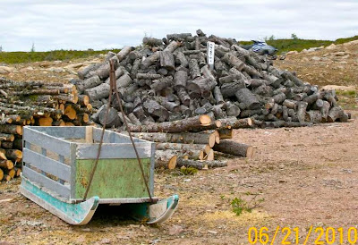
Getting ready for winter, to arrive in 4 months.    Countless firewood piles, box sleds, snowmobiles as in the picture are left at roadside, with no need for concern about security.


Basque whalers had used for ballast from Europe about 400 years ago, and left here. Now there is an elegant Visitors Center, and the precious artifacts are protected.

We were so lucky that June 21, the summer solstice, is Aboriginal Day, and an expert on the peoples who occupied this land centuries ago (and to a lesser extent still do) had come from Goose Bay to talk to visitors. Mr. Winston White's mother was an Inuit ("Eskimo"), so he is fluent in the languages of the Inuit and the Innu ("Indians") and definitely English. He also played the guitar like Johnny Cash, singing a couple of Labrador folk songs, and one he had composed. He tried to teach his small audience the fundamentals of the Inuit language, but left me only with "Na Ku Meek" ("Thank you"), which he richly deserved. 

We stayed the night in a hotel hosting a busload of tourists.  Tomorrow, June 22, we'll take the nearby 90 minute ferry to the island of Newfoundland.   We had seen several small icebergs in the adjacent Belle Isle Strait since Red Bay, and hoped to see a lot more on the road to St. Anthony, at the island's northwest tip.


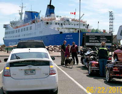
On June 22 we took the ferry from Blanc Sablon, barely inside Quebec, across Belle Isle Strait to Newfoundland..  The 1 1/2 hour crossing  cost us a mere $23.10 Canadian.


This beautiful TV video perfectly captures the charm and beauty of the island of Newfoundland, where our narrative continues:   click here


The private potato patches beside Route 430 in the northwest corner of Newfoundland work on the same honor system as do roadside firewood piles in Newfoundland.  The fence is supposed to keep out moose, and the flapping plastic bags are supposed to scare them off.   The patches are built beside Route 430 because it's convenient and because they use fertile soil stirred up in road building and mostly freed of large rocks and roots.  

We stayed that night in a B&B close by L'Anse aux Meadows, where the Vikings had a brief colony 500 years before Columbus, and where the International Appalachian Trail ends, for now.   We saw only a few small icebergs in "Iceberg Alley" where Newfoundland is closest to Labrador.  We'd seen many more in the summer of 1999, but this year most of the icebergs were blocked on their path from Greenland by about 20 miles of sheet ice off the shore at Cartwright.   The B&B owner provided drinking water because the tap water was so sulphurous.   Isn't sulfur often associated with petroleum ?   It is in Texas.  Hmm....maybe there's a fortune under the ground here.